


047 Gernika Lezama

lucille
User
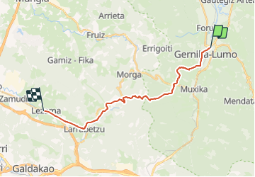

Length
19.8 km

Max alt
336 m

Uphill gradient
590 m
Km-Effort
27 km

Min alt
4 m

Downhill gradient
538 m
Boucle
No
Creation date :
2014-12-10 00:00:00.0
Updated on :
2014-12-10 00:00:00.0
5h48
Difficulty : Unknown

FREE GPS app for hiking
 SityTrail
IGN / Geographical institutes
SityTrail Plus
The world is yours!
About
Trail Walking of 19.8 km to be discovered at Autonomous Community of the Basque Country, Biscay, Guernica. This trail is proposed by lucille.
Description
Gernika / Lezama
Auberge Municipale
Positioning
Country:
Spain
Region :
Autonomous Community of the Basque Country
Department/Province :
Biscay
Municipality :
Guernica
Location:
Unknown
Start:(Dec)
Start:(UTM)
526520 ; 4796293 (30T) N.
Comments