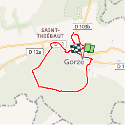
Trail Walking Gorze - Gorze - Photo
© OpenStreetMap contributors
Length
Length
7.3 km
Max alt
Max alt
348 m
Uphill gradient
Uphill gradient
227 m
Km-Effort
Km-Effort  
10.3 km
Min alt
Min alt
198 m
Downhill gradient
Downhill gradient
227 m
Boucle
Boucle
Yes
Creation date :
2014-12-10 00:00:00.0
Updated on :
2014-12-10 00:00:00.0

(0 Reviews)

Walking
Walking
2h11
Difficulty : Medium

Scan this QR Code to open this trail in the SityTrail application

FREE GPS app for hiking

Logo SityTrail SityTrail

IGN / Geographical institutes

Download SityTrail from the App Store Download SityTrail from Google Play

Logo SityTrail SityTrail Plus

The world is yours!

Download SityTrail from the App Store Download SityTrail from Google Play Download SityTrail on Huawei AppGallery

About

Trail Walking of 7.3 km to be discovered at Grand Est, Moselle, Gorze. This trail is proposed by edmondnagel.

Description

Départ parking rue Paul Driant - rue du commerce - on monte vers le mont Saint Belin pour le panorama de Gorze - on descend par la rue de Rezonville - on prend la rue de la Meuse pour passer à côté de l'Abbaye - le cimetière - on passe par la forêt "Les Gros Bois" - Fond de Gueule - Cours de Tennis de Gorze - retour rue du Général de Gaulle - rue de Novéant - arrivée parking rue Paul Driant

Elevation profile

Photos

Positioning

Country:
France
Region :
Grand Est
Department/Province :
Moselle
Municipality :
Gorze
Location:
Unknown
Start:(UTM)
280940 ; 5437584 (32U) N.


Close
My subscriptions