etaples

Bernard.voyageur
User
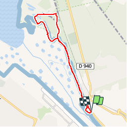

Length
6.8 km

Max alt
9 m

Uphill gradient
23 m
Km-Effort
7.1 km

Min alt
2 m

Downhill gradient
23 m
Boucle
Yes
Creation date :
2016-03-09 00:00:00.0
Updated on :
2016-03-09 00:00:00.0
1h37
Difficulty : Easy

FREE GPS app for hiking
 SityTrail
IGN / Geographical institutes
SityTrail Plus
The world is yours!
About
Trail Walking of 6.8 km to be discovered at Hauts-de-France, Pas-de-Calais, Étaples. This trail is proposed by Bernard.voyageur.
Description
premier pas dans la réserve naturelle de la baie de la Canche
Positioning
Country:
France
Region :
Hauts-de-France
Department/Province :
Pas-de-Calais
Municipality :
Étaples
Location:
Unknown
Start:(Dec)
Start:(UTM)
402840 ; 5597254 (31U) N.
Comments