


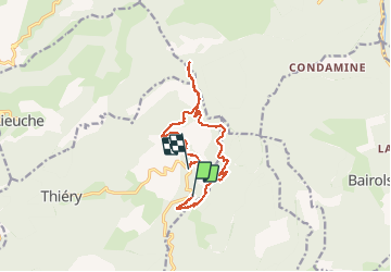
Brec d''Ilonse à partir de la route de Thierry

PEBREJOSIANE
User

Length
14 km

Max alt
1737 m

Uphill gradient
933 m
Km-Effort
26 km

Min alt
935 m

Downhill gradient
864 m
Boucle
No
Creation date :
2014-12-10 00:00:00.0
Updated on :
2014-12-10 00:00:00.0
5h25
Difficulty : Medium

FREE GPS app for hiking
 SityTrail
IGN / Geographical institutes
SityTrail Plus
The world is yours!
About
Trail Walking of 14 km to be discovered at Provence-Alpes-Côte d'Azur, Maritime Alps, Thiéry. This trail is proposed by PEBREJOSIANE.
Description
Randonnée en boucle au milieu de très belles forêts.
Positioning
Country:
France
Region :
Provence-Alpes-Côte d'Azur
Department/Province :
Maritime Alps
Municipality :
Thiéry
Location:
Unknown
Start:(Dec)
Start:(UTM)
345341 ; 4871281 (32T) N.
Comments