


Evry et l'eau

ouargla
User

Length
18.4 km

Max alt
88 m

Uphill gradient
183 m
Km-Effort
21 km

Min alt
29 m

Downhill gradient
185 m
Boucle
Yes
Creation date :
2014-12-10 00:00:00.0
Updated on :
2014-12-10 00:00:00.0
1h12
Difficulty : Very easy

FREE GPS app for hiking
 SityTrail
IGN / Geographical institutes
SityTrail Plus
The world is yours!
About
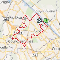
Trail Cycle of 18.4 km to be discovered at Ile-de-France, Essonne, Évry-Courcouronnes. This trail is proposed by ouargla.
Description
Ballade sympa à vélo sur le thème de l'eau. En effet, nous longeons le lavoir, la préfecture, le lac de Courcouronnes, l"Ecoute s'il pleut" et la Seine.
Positioning
Country:
France
Region :
Ile-de-France
Department/Province :
Essonne
Municipality :
Évry-Courcouronnes
Location:
Évry
Start:(Dec)
Start:(UTM)
459191 ; 5387140 (31U) N.
Comments
Très bon
malakoff