


001 Paris Vauhallan

lucille
User
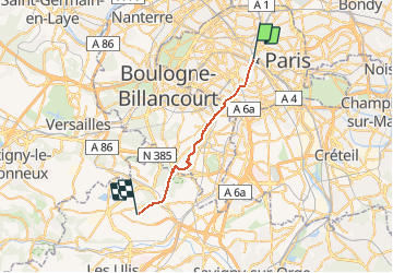

Length
22 km

Max alt
180 m

Uphill gradient
408 m
Km-Effort
27 km

Min alt
29 m

Downhill gradient
316 m
Boucle
No
Creation date :
2014-12-10 00:00:00.0
Updated on :
2014-12-10 00:00:00.0
5h49
Difficulty : Unknown

FREE GPS app for hiking
 SityTrail
IGN / Geographical institutes
SityTrail Plus
The world is yours!
About
Trail Walking of 22 km to be discovered at Ile-de-France, Paris, Paris. This trail is proposed by lucille.
Description
Paris / Vauhallan
Abbaye Saint Louis du Temple
Positioning
Country:
France
Region :
Ile-de-France
Department/Province :
Paris
Municipality :
Paris
Location:
4th Arrondissement
Start:(Dec)
Start:(UTM)
452255 ; 5411899 (31U) N.
Comments