


006 Chartres Thivars

lucille
User
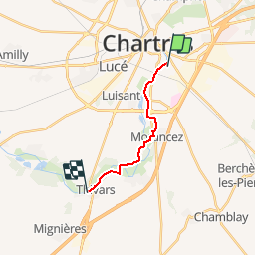

Length
10.3 km

Max alt
152 m

Uphill gradient
95 m
Km-Effort
11.6 km

Min alt
126 m

Downhill gradient
87 m
Boucle
No
Creation date :
2014-12-10 00:00:00.0
Updated on :
2014-12-10 00:00:00.0
2h33
Difficulty : Unknown

FREE GPS app for hiking
 SityTrail
IGN / Geographical institutes
SityTrail Plus
The world is yours!
About
Trail Walking of 10.3 km to be discovered at Centre-Loire Valley, Eure-et-Loir, Chartres. This trail is proposed by lucille.
Description
Chartres Bord de l'Eure / Thivars
Le Kangourou
Positioning
Country:
France
Region :
Centre-Loire Valley
Department/Province :
Eure-et-Loir
Municipality :
Chartres
Location:
Unknown
Start:(Dec)
Start:(UTM)
389075 ; 5365827 (31U) N.
Comments