


008 Bonneval Chateaudun

lucille
User
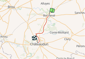

Length
17.3 km

Max alt
152 m

Uphill gradient
139 m
Km-Effort
19.2 km

Min alt
105 m

Downhill gradient
157 m
Boucle
No
Creation date :
2014-12-10 00:00:00.0
Updated on :
2014-12-10 00:00:00.0
4h13
Difficulty : Unknown

FREE GPS app for hiking
 SityTrail
IGN / Geographical institutes
SityTrail Plus
The world is yours!
About
Trail Walking of 17.3 km to be discovered at Centre-Loire Valley, Eure-et-Loir, Bonneval. This trail is proposed by lucille.
Description
Bonneval / Châteaudun
Camping municipal
Positioning
Country:
France
Region :
Centre-Loire Valley
Department/Province :
Eure-et-Loir
Municipality :
Bonneval
Location:
Unknown
Start:(Dec)
Start:(UTM)
380026 ; 5337678 (31U) N.
Comments