


009 Chateaudun Cloyes

lucille
User
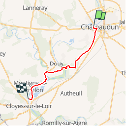

Length
13.6 km

Max alt
143 m

Uphill gradient
103 m
Km-Effort
15 km

Min alt
95 m

Downhill gradient
120 m
Boucle
No
Creation date :
2014-12-10 00:00:00.0
Updated on :
2014-12-10 00:00:00.0
3h19
Difficulty : Unknown

FREE GPS app for hiking
 SityTrail
IGN / Geographical institutes
SityTrail Plus
The world is yours!
About
Trail Walking of 13.6 km to be discovered at Centre-Loire Valley, Eure-et-Loir, Châteaudun. This trail is proposed by lucille.
Description
Châteaudun / Cloyes sur Loir
Camping Val fleuri
Positioning
Country:
France
Region :
Centre-Loire Valley
Department/Province :
Eure-et-Loir
Municipality :
Châteaudun
Location:
Unknown
Start:(Dec)
Start:(UTM)
375037 ; 5325492 (31U) N.
Comments