


011 Vendome Villechauve

lucille
User
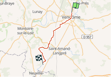

Length
29 km

Max alt
139 m

Uphill gradient
286 m
Km-Effort
33 km

Min alt
80 m

Downhill gradient
263 m
Boucle
No
Creation date :
2014-12-10 00:00:00.0
Updated on :
2014-12-10 00:00:00.0
7h08
Difficulty : Unknown

FREE GPS app for hiking
 SityTrail
IGN / Geographical institutes
SityTrail Plus
The world is yours!
About
Trail Walking of 29 km to be discovered at Centre-Loire Valley, Loir-et-Cher, Vendôme. This trail is proposed by lucille.
Description
Vendôme / Villechauve


Positioning
Country:
France
Region :
Centre-Loire Valley
Department/Province :
Loir-et-Cher
Municipality :
Vendôme
Location:
Unknown
Start:(Dec)
Start:(UTM)
355386 ; 5296693 (31T) N.
Comments