


012 Villechauve Villedomer

lucille
User
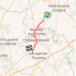

Length
15.9 km

Max alt
122 m

Uphill gradient
179 m
Km-Effort
18.4 km

Min alt
78 m

Downhill gradient
217 m
Boucle
No
Creation date :
2014-12-10 00:00:00.0
Updated on :
2014-12-10 00:00:00.0
3h59
Difficulty : Unknown

FREE GPS app for hiking
 SityTrail
IGN / Geographical institutes
SityTrail Plus
The world is yours!
About
Trail Walking of 15.9 km to be discovered at Centre-Loire Valley, Loir-et-Cher, Villechauve. This trail is proposed by lucille.
Description
Villechauve / Villedômer
Gîte Route d'Azouër, La Hémond


Positioning
Country:
France
Region :
Centre-Loire Valley
Department/Province :
Loir-et-Cher
Municipality :
Villechauve
Location:
Unknown
Start:(Dec)
Start:(UTM)
345425 ; 5279275 (31T) N.
Comments