


Olne Spa Olne 2012

SERGIO110_1
User
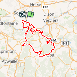

Length
66 km

Max alt
380 m

Uphill gradient
1864 m
Km-Effort
91 km

Min alt
104 m

Downhill gradient
1863 m
Boucle
Yes
Creation date :
2014-12-10 00:00:00.0
Updated on :
2014-12-10 00:00:00.0
--
Difficulty : Difficult

FREE GPS app for hiking
 SityTrail
IGN / Geographical institutes
SityTrail Plus
The world is yours!
About
Trail Running of 66 km to be discovered at Wallonia, Liège, Olne. This trail is proposed by SERGIO110_1.
Positioning
Country:
Belgium
Region :
Wallonia
Department/Province :
Liège
Municipality :
Olne
Location:
Olne
Start:(Dec)
Start:(UTM)
694843 ; 5607893 (31U) N.
Comments