


026 Saintes Pons

lucille
User
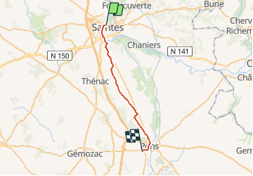

Length
24 km

Max alt
67 m

Uphill gradient
215 m
Km-Effort
27 km

Min alt
4 m

Downhill gradient
205 m
Boucle
No
Creation date :
2014-12-10 00:00:00.0
Updated on :
2014-12-10 00:00:00.0
5h57
Difficulty : Unknown

FREE GPS app for hiking
 SityTrail
IGN / Geographical institutes
SityTrail Plus
The world is yours!
About
Trail Walking of 24 km to be discovered at New Aquitaine, Charente-Maritime, Saintes. This trail is proposed by lucille.
Description
Saintes / Pons
Positioning
Country:
France
Region :
New Aquitaine
Department/Province :
Charente-Maritime
Municipality :
Saintes
Location:
Unknown
Start:(Dec)
Start:(UTM)
684242 ; 5068438 (30T) N.
Comments