


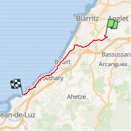
040 Bayonne Saint Jean de Luz

lucille
User

Length
13.8 km

Max alt
76 m

Uphill gradient
224 m
Km-Effort
17 km

Min alt
0 m

Downhill gradient
292 m
Boucle
No
Creation date :
2014-12-10 00:00:00.0
Updated on :
2014-12-10 00:00:00.0
4h30
Difficulty : Unknown

FREE GPS app for hiking
 SityTrail
IGN / Geographical institutes
SityTrail Plus
The world is yours!
About
Trail Walking of 13.8 km to be discovered at New Aquitaine, Pyrénées-Atlantiques, Anglet. This trail is proposed by lucille.
Description
Bayonne / Saint Jean de Luz
Camping Bord de Mer
Positioning
Country:
France
Region :
New Aquitaine
Department/Province :
Pyrénées-Atlantiques
Municipality :
Anglet
Location:
Unknown
Start:(Dec)
Start:(UTM)
618742 ; 4813441 (30T) N.
Comments