


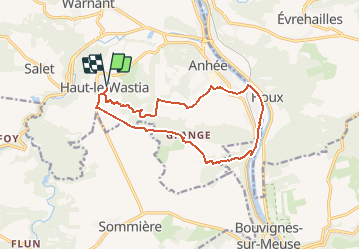
Haut-le-Wastia mai 40 via Mont Anhee 12.4

pjjrevrard
User

Length
12.4 km

Max alt
246 m

Uphill gradient
252 m
Km-Effort
15.8 km

Min alt
86 m

Downhill gradient
252 m
Boucle
Yes
Creation date :
2014-12-10 00:00:00.0
Updated on :
2014-12-10 00:00:00.0
3h00
Difficulty : Medium

FREE GPS app for hiking
 SityTrail
IGN / Geographical institutes
SityTrail Plus
The world is yours!
About
Trail Walking of 12.4 km to be discovered at Wallonia, Namur, Anhée. This trail is proposed by pjjrevrard.
Description
ATTENTION: ce tracé passe en partie par une propriété privée. Pour éviter ce passage, il suffit, à la chapelle St-Antoine de tourner directement à droite et de longer la propriété privée de Mont d''Anhée
Positioning
Country:
Belgium
Region :
Wallonia
Department/Province :
Namur
Municipality :
Anhée
Location:
Haut-le-Wastia
Start:(Dec)
Start:(UTM)
631226 ; 5574223 (31U) N.
Comments