2011-12-25 17h13m46

trailer.nono
User
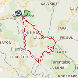

Length
14.8 km

Max alt
1094 m

Uphill gradient
528 m
Km-Effort
22 km

Min alt
718 m

Downhill gradient
522 m
Boucle
Yes
Creation date :
2014-12-10 00:00:00.0
Updated on :
2014-12-10 00:00:00.0
1h41
Difficulty : Medium

FREE GPS app for hiking
 SityTrail
IGN / Geographical institutes
SityTrail Plus
The world is yours!
About
Trail Running of 14.8 km to be discovered at Auvergne-Rhône-Alpes, Loire, Saint-Étienne. This trail is proposed by trailer.nono.
Positioning
Country:
France
Region :
Auvergne-Rhône-Alpes
Department/Province :
Loire
Municipality :
Saint-Étienne
Location:
Rochetaillée
Start:(Dec)
Start:(UTM)
613164 ; 5029118 (31T) N.
Comments