


Roncherolle

RC76
User
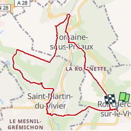

Length
10 km

Max alt
165 m

Uphill gradient
244 m
Km-Effort
13.2 km

Min alt
51 m

Downhill gradient
243 m
Boucle
Yes
Creation date :
2014-12-10 00:00:00.0
Updated on :
2014-12-10 00:00:00.0
--
Difficulty : Medium

FREE GPS app for hiking
 SityTrail
IGN / Geographical institutes
SityTrail Plus
The world is yours!
About
Trail Walking of 10 km to be discovered at Normandy, Seine-Maritime, Roncherolles-sur-le-Vivier. This trail is proposed by RC76.
Positioning
Country:
France
Region :
Normandy
Department/Province :
Seine-Maritime
Municipality :
Roncherolles-sur-le-Vivier
Location:
Unknown
Start:(Dec)
Start:(UTM)
368355 ; 5481010 (31U) N.
Comments