


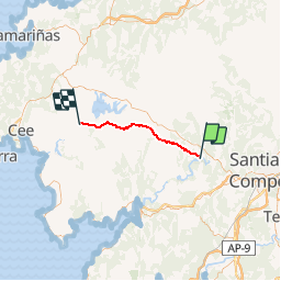
078 Negreira Olveiroa

lucille
User

Length
31 km

Max alt
428 m

Uphill gradient
696 m
Km-Effort
40 km

Min alt
148 m

Downhill gradient
594 m
Boucle
No
Creation date :
2014-12-10 00:00:00.0
Updated on :
2014-12-10 00:00:00.0
8h32
Difficulty : Unknown

FREE GPS app for hiking
 SityTrail
IGN / Geographical institutes
SityTrail Plus
The world is yours!
About
Trail Walking of 31 km to be discovered at Galicia, A Coruña, Negreira. This trail is proposed by lucille.
Description
Negreira / Olveiroa
Auberge municipale
Positioning
Country:
Spain
Region :
Galicia
Department/Province :
A Coruña
Municipality :
Negreira
Location:
Negreira
Start:(Dec)
Start:(UTM)
521151 ; 4750114 (29T) N.
Comments