


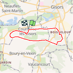
Courcelles-lès-Gisors - Le Boisgeloup

marcel.F
User

Length
11.1 km

Max alt
149 m

Uphill gradient
126 m
Km-Effort
12.8 km

Min alt
68 m

Downhill gradient
126 m
Boucle
Yes
Creation date :
2016-11-06 00:00:00.0
Updated on :
2019-04-05 20:17:19.045
2h49
Difficulty : Easy

FREE GPS app for hiking
 SityTrail
IGN / Geographical institutes
SityTrail Plus
The world is yours!
About
Trail Walking of 11.1 km to be discovered at Hauts-de-France, Oise, Courcelles-lès-Gisors. This trail is proposed by marcel.F.
Description
Boucle au départ parking salle des fêtes de Courcelles-les Gisors via le Boisgeloup et Mauréaumont
Positioning
Country:
France
Region :
Hauts-de-France
Department/Province :
Oise
Municipality :
Courcelles-lès-Gisors
Location:
Unknown
Start:(Dec)
Start:(UTM)
408576 ; 5457233 (31U) N.
Comments
i ok
T B