


LA CAPELETE PAR ST STAPIN

CANON2
User
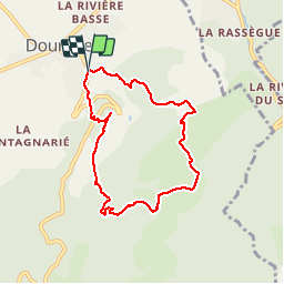

Length
7.3 km

Max alt
595 m

Uphill gradient
391 m
Km-Effort
12.6 km

Min alt
262 m

Downhill gradient
393 m
Boucle
Yes
Creation date :
2019-05-15 13:11:09.005
Updated on :
2019-05-15 13:11:09.329
2h37
Difficulty : Easy

FREE GPS app for hiking
 SityTrail
IGN / Geographical institutes
SityTrail Plus
The world is yours!
About
Trail Walking of 7.3 km to be discovered at Occitania, Tarn, Dourgne. This trail is proposed by CANON2.
Points of interest


Positioning
Country:
France
Region :
Occitania
Department/Province :
Tarn
Municipality :
Dourgne
Location:
Unknown
Start:(Dec)
Start:(UTM)
430516 ; 4814762 (31T) N.
Comments