


12-01-2013

fredodlageo
User
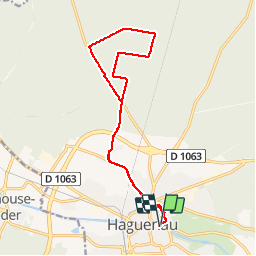

Length
15.6 km

Max alt
186 m

Uphill gradient
130 m
Km-Effort
17.4 km

Min alt
134 m

Downhill gradient
129 m
Boucle
Yes
Creation date :
2014-12-10 00:00:00.0
Updated on :
2014-12-10 00:00:00.0
47m
Difficulty : Very easy

FREE GPS app for hiking
 SityTrail
IGN / Geographical institutes
SityTrail Plus
The world is yours!
About
Trail Cycle of 15.6 km to be discovered at Grand Est, Bas-Rhin, Haguenau. This trail is proposed by fredodlageo.
Description
sortie cyclo-cross
Positioning
Country:
France
Region :
Grand Est
Department/Province :
Bas-Rhin
Municipality :
Haguenau
Location:
Unknown
Start:(Dec)
Start:(UTM)
411515 ; 5407796 (32U) N.
Comments