


LES GORGES DE COLOMBIERES

CANON2
User
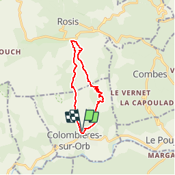

Length
10.3 km

Max alt
839 m

Uphill gradient
653 m
Km-Effort
19 km

Min alt
219 m

Downhill gradient
655 m
Boucle
Yes
Creation date :
2019-05-15 13:11:08.07
Updated on :
2019-05-15 13:11:08.256
3h58
Difficulty : Difficult

FREE GPS app for hiking
 SityTrail
IGN / Geographical institutes
SityTrail Plus
The world is yours!
About
Trail Walking of 10.3 km to be discovered at Occitania, Hérault, Colombières-sur-Orb. This trail is proposed by CANON2.


Positioning
Country:
France
Region :
Occitania
Department/Province :
Hérault
Municipality :
Colombières-sur-Orb
Location:
Unknown
Start:(Dec)
Start:(UTM)
500972 ; 4825427 (31T) N.
Comments
bien