


2013-01-14 Rando Galette Breuillet Village

jchezlemas
User
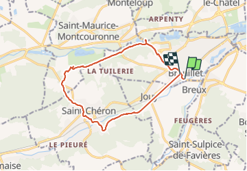

Length
13.4 km

Max alt
145 m

Uphill gradient
202 m
Km-Effort
16.1 km

Min alt
56 m

Downhill gradient
198 m
Boucle
No
Creation date :
2014-12-10 00:00:00.0
Updated on :
2014-12-10 00:00:00.0
3h31
Difficulty : Easy

FREE GPS app for hiking
 SityTrail
IGN / Geographical institutes
SityTrail Plus
The world is yours!
About
Trail Walking of 13.4 km to be discovered at Ile-de-France, Essonne, Breuillet. This trail is proposed by jchezlemas.
Positioning
Country:
France
Region :
Ile-de-France
Department/Province :
Essonne
Municipality :
Breuillet
Location:
Unknown
Start:(Dec)
Start:(UTM)
438968 ; 5379422 (31U) N.
Comments