


Col de Fontfroide

CANON2
User
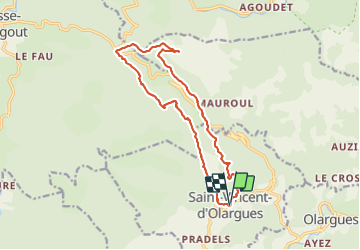

Length
16.4 km

Max alt
984 m

Uphill gradient
804 m
Km-Effort
27 km

Min alt
313 m

Downhill gradient
803 m
Boucle
Yes
Creation date :
2019-05-15 13:11:03.349
Updated on :
2019-05-15 13:11:03.552
5h37
Difficulty : Difficult

FREE GPS app for hiking
 SityTrail
IGN / Geographical institutes
SityTrail Plus
The world is yours!
About
Trail Walking of 16.4 km to be discovered at Occitania, Hérault, Saint-Vincent-d'Olargues. This trail is proposed by CANON2.
Positioning
Country:
France
Region :
Occitania
Department/Province :
Hérault
Municipality :
Saint-Vincent-d'Olargues
Location:
Unknown
Start:(Dec)
Start:(UTM)
490236 ; 4823091 (31T) N.
Comments