


La Ramade

CANON2
User
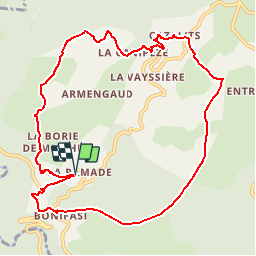

Length
11.3 km

Max alt
739 m

Uphill gradient
347 m
Km-Effort
15.9 km

Min alt
496 m

Downhill gradient
349 m
Boucle
Yes
Creation date :
2019-05-15 13:10:45.899
Updated on :
2019-05-15 13:10:46.05
3h10
Difficulty : Easy

FREE GPS app for hiking
 SityTrail
IGN / Geographical institutes
SityTrail Plus
The world is yours!
About
Trail Walking of 11.3 km to be discovered at Occitania, Tarn, Fontrieu. This trail is proposed by CANON2.
Positioning
Country:
France
Region :
Occitania
Department/Province :
Tarn
Municipality :
Fontrieu
Location:
Ferrières
Start:(Dec)
Start:(UTM)
455538 ; 4834483 (31T) N.
Comments