


sur les hauteur de st ferreol

CANON2
User
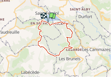

Length
13 km

Max alt
629 m

Uphill gradient
344 m
Km-Effort
17.6 km

Min alt
327 m

Downhill gradient
342 m
Boucle
Yes
Creation date :
2019-05-15 13:10:42.229
Updated on :
2019-05-15 13:10:42.275
3h20
Difficulty : Easy

FREE GPS app for hiking
 SityTrail
IGN / Geographical institutes
SityTrail Plus
The world is yours!
About
Trail Walking of 13 km to be discovered at Occitania, Haute-Garonne, Vaudreuille. This trail is proposed by CANON2.
Positioning
Country:
France
Region :
Occitania
Department/Province :
Haute-Garonne
Municipality :
Vaudreuille
Location:
Unknown
Start:(Dec)
Start:(UTM)
421119 ; 4809363 (31T) N.
Comments