
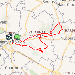
Magny en Vexin - Nucourt

marcel.F
User

Length
13.9 km

Max alt
137 m

Uphill gradient
143 m
Km-Effort
15.8 km

Min alt
72 m

Downhill gradient
144 m
Boucle
Yes
Creation date :
2014-12-10 00:00:00.0
Updated on :
2019-04-15 15:39:45.423
3h29
Difficulty : Easy

FREE GPS app for hiking
 SityTrail
IGN / Geographical institutes
SityTrail Plus
The world is yours!
About
Trail Walking of 13.9 km to be discovered at Ile-de-France, Val-d'Oise, Magny-en-Vexin. This trail is proposed by marcel.F.
Description
Départ parking place de l'Europe à Magny-en-Vexin. L'église de Nucourt par le bois de l'ile
Photos


Positioning
Country:
France
Region :
Ile-de-France
Department/Province :
Val-d'Oise
Municipality :
Magny-en-Vexin
Location:
Unknown
Start:(Dec)
Start:(UTM)
411757 ; 5445340 (31U) N.
Comments