LE ROC DU MONTALET

CANON2
User
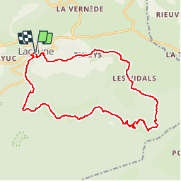

Length
18.3 km

Max alt
1248 m

Uphill gradient
573 m
Km-Effort
26 km

Min alt
804 m

Downhill gradient
575 m
Boucle
Yes
Creation date :
2019-05-15 13:10:36.579
Updated on :
2019-05-15 13:10:36.65
5h27
Difficulty : Difficult

FREE GPS app for hiking
 SityTrail
IGN / Geographical institutes
SityTrail Plus
The world is yours!
About
Trail Walking of 18.3 km to be discovered at Occitania, Tarn, Lacaune. This trail is proposed by CANON2.
Positioning
Country:
France
Region :
Occitania
Department/Province :
Tarn
Municipality :
Lacaune
Location:
Unknown
Start:(Dec)
Start:(UTM)
475101 ; 4839292 (31T) N.
Comments