


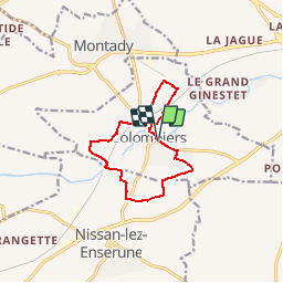
COLOMBIERS

CANON2
User

Length
10.8 km

Max alt
69 m

Uphill gradient
99 m
Km-Effort
12.1 km

Min alt
18 m

Downhill gradient
101 m
Boucle
Yes
Creation date :
2019-05-15 13:10:29.487
Updated on :
2019-05-15 13:10:29.554
2h10
Difficulty : Very easy

FREE GPS app for hiking
 SityTrail
IGN / Geographical institutes
SityTrail Plus
The world is yours!
About
Trail Walking of 10.8 km to be discovered at Occitania, Hérault, Colombiers. This trail is proposed by CANON2.
Positioning
Country:
France
Region :
Occitania
Department/Province :
Hérault
Municipality :
Colombiers
Location:
Unknown
Start:(Dec)
Start:(UTM)
511561 ; 4795614 (31T) N.
Comments