Trail Walking Méasnes - Circuit de sources - Méasnes - Photo

Circuit de sources - Méasnes

 tracegps
tracegps

User

© OpenStreetMap contributors
Length
Length
12 km
Max alt
Max alt
422 m
Uphill gradient
Uphill gradient
185 m
Km-Effort
Km-Effort  
14.5 km
Min alt
Min alt
327 m
Downhill gradient
Downhill gradient
181 m
Boucle
Boucle
Yes
Creation date :
2014-12-10 00:00:00.0
Updated on :
2014-12-10 00:00:00.0

(0 Reviews)

Walking
Walking
1h30
Difficulty : Medium

Scan this QR Code to open this trail in the SityTrail application

FREE GPS app for hiking

Logo SityTrail SityTrail

IGN / Geographical institutes

Download SityTrail from the App Store Download SityTrail from Google Play

Logo SityTrail SityTrail World

The world is yours!

Download SityTrail from the App Store Download SityTrail from Google Play Download SityTrail on Huawei AppGallery

About

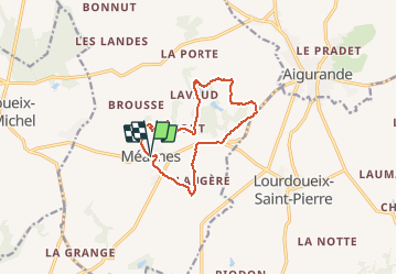
Trail Walking of 12 km to be discovered at New Aquitaine, Creuse, Méasnes. This trail is proposed by tracegps.

Description

Départ de la mairie de Méasnes. Circuit vallonné ou vous aurez une vue sur le massif du Sancy en fin de randonnée.

Elevation profile

Photos

Positioning

Country:
France
Region :
New Aquitaine
Department/Province :
Creuse
Municipality :
Méasnes
Location:
Unknown
Start:(UTM)
406029 ; 5141031 (31T) N.

Trails nearby

Trail Walking Lourdoueix-Saint-Michel - Circuit pédestre des 3 chapelles - Photo
Walking
fanthou

Walking

Easy
Lourdoueix-Saint-Michel, Centre-Loire Valley, Indre, France
6.3 km | 7.4 km-effort
1h 40min
Yes
Trail Walking Aigurande - Circuit pédestre
Walking
fanthou

Walking

Medium
Aigurande, Centre-Loire Valley, Indre, France
7.7 km | 9.3 km-effort
2h 7min
Yes
Trail Walking Aigurande - Aigurande Seuvy St Sépulcre  - Photo
Walking
Estéban MANZANO

Walking

Very difficult
Aigurande, Centre-Loire Valley, Indre, France
19.1 km | 21 km-effort
6h 26min
No
Trail Walking Aigurande - SityTrail - aigurande ,la Vau vre - Photo
Walking
GUIDE
jeanmarcMasson

Walking

Difficult
Aigurande, Centre-Loire Valley, Indre, France
12.3 km | 15.4 km-effort
3h 30min
Yes
Trail Walking Aigurande - Nature, verdure, bouchures - Photo
Walking
fanthou

Walking

Easy
Aigurande, Centre-Loire Valley, Indre, France
4.3 km | 5.4 km-effort
1h 13min
Yes
Trail Walking Aigurande - SityTrail - aigurande ,la Vau vre - Photo
Walking
fanthou

Walking

Easy
Aigurande, Centre-Loire Valley, Indre, France
5.6 km | 6.9 km-effort
1h 33min
Yes
Trail Walking Méasnes - Circuit ME1 : Circuit du Bourg - Photo
Walking
fanthou

Walking

Easy
Méasnes, New Aquitaine, Creuse, France
4.8 km | 6 km-effort
1h 21min
Yes
Trail Walking Méasnes - Circuit ME2 : Circuit des Sources - Photo
Walking
fanthou

Walking

Medium
Méasnes, New Aquitaine, Creuse, France
13.8 km | 17.1 km-effort
3h 52min
Yes
Trail Walking Lourdoueix-Saint-Pierre - Circuit LSP4 : Circuit de la Font du Beau - Photo
Walking
fanthou

Walking

Medium
Lourdoueix-Saint-Pierre, New Aquitaine, Creuse, France
22 km | 25 km-effort
5h 47min
Yes


Close
My subscriptions