


Aigle montagne

Alfredy
User GUIDE
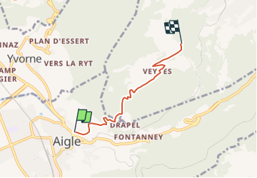

Length
3.9 km

Max alt
1226 m

Uphill gradient
805 m
Km-Effort
12 km

Min alt
419 m

Downhill gradient
9 m
Boucle
No
Creation date :
2014-12-11 00:00:00.0
Updated on :
2014-12-11 00:00:00.0
58m
Difficulty : Unknown

FREE GPS app for hiking
 SityTrail
IGN / Geographical institutes
SityTrail Plus
The world is yours!
About
Trail Walking of 3.9 km to be discovered at Vaud, District d'Aigle, Aigle. This trail is proposed by Alfredy.


Positioning
Country:
Switzerland
Region :
Vaud
Department/Province :
District d'Aigle
Municipality :
Aigle
Location:
Unknown
Start:(Dec)
Start:(UTM)
343783 ; 5131547 (32T) N.
Comments