


Randonnée autour de Carnac

tracegps
User


2h45
Difficulty : Medium

FREE GPS app for hiking
 SityTrail
IGN / Geographical institutes
SityTrail Plus
The world is yours!
About
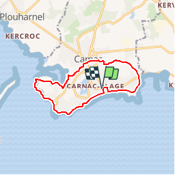
Trail Walking of 11.2 km to be discovered at Brittany, Morbihan, Carnac. This trail is proposed by tracegps.
Description
Départ de l'office de Tourisme de Carnac, avenue des Druides. Après avoir longé la grande plage, on emprunte le chemin des douaniers jusqu'à la pointe du Pô. Ensuite direction la fontaine de St-Colomban pour rejoindre le centre de Carnac. De-là on rejoint, en laissant sur notre gauche le tumulus St Michel, la D186 pour rattraper la digue de Carnac.
Photos


Positioning
Comments