


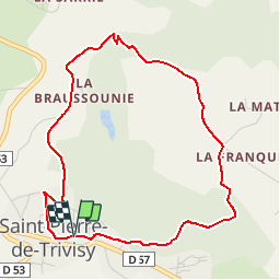
Le moulin de la Broussonié

CANON2
User

Length
4.8 km

Max alt
634 m

Uphill gradient
187 m
Km-Effort
7.3 km

Min alt
490 m

Downhill gradient
187 m
Boucle
Yes
Creation date :
2019-05-15 13:10:27.771
Updated on :
2019-05-15 13:10:27.81
2h25
Difficulty : Very easy

FREE GPS app for hiking
 SityTrail
IGN / Geographical institutes
SityTrail Plus
The world is yours!
About
Trail Walking of 4.8 km to be discovered at Occitania, Tarn, Saint-Pierre-de-Trivisy. This trail is proposed by CANON2.
Positioning
Country:
France
Region :
Occitania
Department/Province :
Tarn
Municipality :
Saint-Pierre-de-Trivisy
Location:
Unknown
Start:(Dec)
Start:(UTM)
454577 ; 4845525 (31T) N.
Comments