


chemin de Travanet

CANON2
User

Length
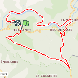
12.7 km

Max alt
491 m

Uphill gradient
346 m
Km-Effort
17.3 km

Min alt
252 m

Downhill gradient
345 m
Boucle
Yes
Creation date :
2019-05-15 13:10:22.452
Updated on :
2019-05-15 13:10:22.496
3h00
Difficulty : Medium

FREE GPS app for hiking
 SityTrail
IGN / Geographical institutes
SityTrail Plus
The world is yours!
About
Trail Walking of 12.7 km to be discovered at Occitania, Tarn, Terre-de-Bancalié. This trail is proposed by CANON2.
Positioning
Country:
France
Region :
Occitania
Department/Province :
Tarn
Municipality :
Terre-de-Bancalié
Location:
Saint-Antonin-de-Lacalm
Start:(Dec)
Start:(UTM)
442772 ; 4845744 (31T) N.
Comments