


Chemin des Crêtes

CANON2
User
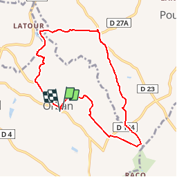

Length
8.4 km

Max alt
249 m

Uphill gradient
162 m
Km-Effort
10.6 km

Min alt
198 m

Downhill gradient
162 m
Boucle
Yes
Creation date :
2019-05-15 13:10:22.075
Updated on :
2019-05-15 13:10:22.113
2h15
Difficulty : Easy

FREE GPS app for hiking
 SityTrail
IGN / Geographical institutes
SityTrail Plus
The world is yours!
About
Trail Walking of 8.4 km to be discovered at Occitania, Tarn, Orban. This trail is proposed by CANON2.
Positioning
Country:
France
Region :
Occitania
Department/Province :
Tarn
Municipality :
Orban
Location:
Unknown
Start:(Dec)
Start:(UTM)
426340 ; 4854771 (31T) N.
Comments
très beau circuit