


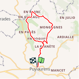
Boucle d'En Gibaud

CANON2
User

Length
14.5 km

Max alt
340 m

Uphill gradient
364 m
Km-Effort
19.3 km

Min alt
181 m

Downhill gradient
359 m
Boucle
Yes
Creation date :
2019-05-15 13:10:17.749
Updated on :
2019-05-15 13:10:17.793
4h06
Difficulty : Medium

FREE GPS app for hiking
 SityTrail
IGN / Geographical institutes
SityTrail Plus
The world is yours!
About
Trail Walking of 14.5 km to be discovered at Occitania, Tarn, Puylaurens. This trail is proposed by CANON2.
Positioning
Country:
France
Region :
Occitania
Department/Province :
Tarn
Municipality :
Puylaurens
Location:
Unknown
Start:(Dec)
Start:(UTM)
420077 ; 4825034 (31T) N.
Comments