


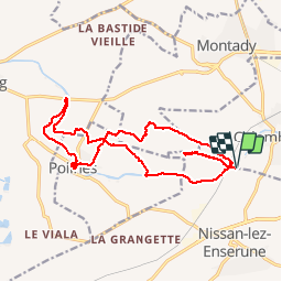
Le tour de l'Oppidum d'Enserude par Poilhes

jdelettrez
User


5h01
Difficulty : Easy

FREE GPS app for hiking
 SityTrail
IGN / Geographical institutes
SityTrail Plus
The world is yours!
About
Trail Walking of 19.4 km to be discovered at Occitania, Hérault, Colombiers. This trail is proposed by jdelettrez.
Description
Le tour de l'Oppidum en variant le paysage par les vignes et le canal du Midi jusqu’à Poilhes. Retour en passant au tunnel de Malpas et visite du site archéologique.(Gratuit le 1ier dimanche de chaque mois hors saison)
Partir du parking de la maison du Malpas

Positioning
Comments