


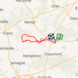
Florennes L136 St Aubin foret domaniale

pjjrevrard
User

Length
14.2 km

Max alt
291 m

Uphill gradient
169 m
Km-Effort
16.5 km

Min alt
233 m

Downhill gradient
169 m
Boucle
Yes
Creation date :
2014-12-10 00:00:00.0
Updated on :
2014-12-10 00:00:00.0
3h40
Difficulty : Unknown

FREE GPS app for hiking
 SityTrail
IGN / Geographical institutes
SityTrail Plus
The world is yours!
About
Trail Other activity of 14.2 km to be discovered at Wallonia, Namur, Florennes. This trail is proposed by pjjrevrard.
Positioning
Country:
Belgium
Region :
Wallonia
Department/Province :
Namur
Municipality :
Florennes
Location:
Florennes
Start:(Dec)
Start:(UTM)
615285 ; 5567286 (31U) N.
Comments