


CREPY EN VALOIS - MORIENVAL EN BOUCLE

NUITEVEN
User
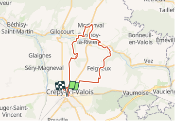

Length
28 km

Max alt
128 m

Uphill gradient
398 m
Km-Effort
33 km

Min alt
52 m

Downhill gradient
398 m
Boucle
Yes
Creation date :
2014-12-10 00:00:00.0
Updated on :
2014-12-10 00:00:00.0
7h06
Difficulty : Easy

FREE GPS app for hiking
 SityTrail
IGN / Geographical institutes
SityTrail Plus
The world is yours!
About
Trail Walking of 28 km to be discovered at Hauts-de-France, Oise, Crépy-en-Valois. This trail is proposed by NUITEVEN.
Positioning
Country:
France
Region :
Hauts-de-France
Department/Province :
Oise
Municipality :
Crépy-en-Valois
Location:
Unknown
Start:(Dec)
Start:(UTM)
491746 ; 5453186 (31U) N.
Comments