


Circuit des Devèzes

CANON2
User
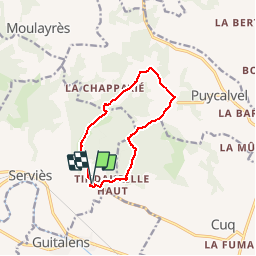

Length
10 km

Max alt
334 m

Uphill gradient
213 m
Km-Effort
12.9 km

Min alt
171 m

Downhill gradient
213 m
Boucle
Yes
Creation date :
2019-05-15 13:10:14.289
Updated on :
2019-05-15 13:10:14.372
2h40
Difficulty : Easy

FREE GPS app for hiking
 SityTrail
IGN / Geographical institutes
SityTrail Plus
The world is yours!
About
Trail Walking of 10 km to be discovered at Occitania, Tarn, Serviès. This trail is proposed by CANON2.
Positioning
Country:
France
Region :
Occitania
Department/Province :
Tarn
Municipality :
Serviès
Location:
Unknown
Start:(Dec)
Start:(UTM)
423237 ; 4834315 (31T) N.
Comments