


bagenellles

pedro54
User
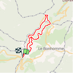

Length
14.6 km

Max alt
1108 m

Uphill gradient
459 m
Km-Effort
21 km

Min alt
854 m

Downhill gradient
451 m
Boucle
Yes
Creation date :
2014-12-10 00:00:00.0
Updated on :
2014-12-10 00:00:00.0
6h40
Difficulty : Medium

FREE GPS app for hiking
 SityTrail
IGN / Geographical institutes
SityTrail Plus
The world is yours!
About
Trail Snowshoes of 14.6 km to be discovered at Grand Est, Vosges, Plainfaing. This trail is proposed by pedro54.
Description
Rando en raquette départ du col du Bonhomme, première partie sur les crêtes puis retour sur le flanc de colline sur un chemin forestier puis à travers champs. Multiples pauses en route.
Positioning
Country:
France
Region :
Grand Est
Department/Province :
Vosges
Municipality :
Plainfaing
Location:
Unknown
Start:(Dec)
Start:(UTM)
357194 ; 5336429 (32U) N.
Comments