


S-J-TOULOUSE-PIBRAC 2

CANON2
User
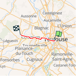

Length
15.5 km

Max alt
191 m

Uphill gradient
170 m
Km-Effort
17.6 km

Min alt
129 m

Downhill gradient
133 m
Boucle
No
Creation date :
2019-05-15 13:10:11.822
Updated on :
2019-05-15 13:10:11.869
4h00
Difficulty : Easy

FREE GPS app for hiking
 SityTrail
IGN / Geographical institutes
SityTrail Plus
The world is yours!
About
Trail Walking of 15.5 km to be discovered at Occitania, Haute-Garonne, Toulouse. This trail is proposed by CANON2.
Positioning
Country:
France
Region :
Occitania
Department/Province :
Haute-Garonne
Municipality :
Toulouse
Location:
Unknown
Start:(Dec)
Start:(UTM)
374027 ; 4828728 (31T) N.
Comments