


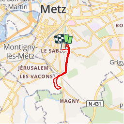
Metz - Bord de Seille

edmondnagel
User


1h54
Difficulty : Easy

FREE GPS app for hiking
 SityTrail
IGN / Geographical institutes
SityTrail Plus
The world is yours!
About
Trail Walking of 8 km to be discovered at Grand Est, Moselle, Metz. This trail is proposed by edmondnagel.
Description
Départ piscine Lothaire, direction Magny, en prolongement de la rue Georges Ducrocp, rive droite de la Seille jusqu'au vieux pont, puis retour par la rive gauche de la Seille jusqu'à la piscine Lothaire, pour aller vers les Arènes, par le parc de la Seille, on traverse la passerelle Graoully et retour par la rive droite de la Seille jusqu'à la piscine Lothaire
Photos


Positioning
Comments