


trip velo vtt

hagan
User

Length
33 km

Max alt
33 m

Uphill gradient
139 m
Km-Effort
35 km

Min alt
16 m

Downhill gradient
140 m
Boucle
Yes
Creation date :
2014-12-10 00:00:00.0
Updated on :
2014-12-10 00:00:00.0
2h23
Difficulty : Difficult

FREE GPS app for hiking
 SityTrail
IGN / Geographical institutes
SityTrail Plus
The world is yours!
About
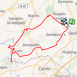
Trail Mountain bike of 33 km to be discovered at Hauts-de-France, Nord, Seclin. This trail is proposed by hagan.
Description
Note : Pour du VTT, préférer l'autre berge du canal de la Deule que celle indiquée sur ce guide. Pavés en fin de parcours.
Positioning
Country:
France
Region :
Hauts-de-France
Department/Province :
Nord
Municipality :
Seclin
Location:
Unknown
Start:(Dec)
Start:(UTM)
500799 ; 5600000 (31U) N.
Comments