


pond entier

phiphi21500
User
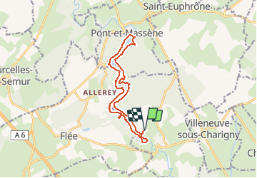

Length
14.2 km

Max alt
319 m

Uphill gradient
189 m
Km-Effort
16.7 km

Min alt
286 m

Downhill gradient
189 m
Boucle
Yes
Creation date :
2014-12-10 00:00:00.0
Updated on :
2014-12-10 00:00:00.0
3h42
Difficulty : Medium

FREE GPS app for hiking
 SityTrail
IGN / Geographical institutes
SityTrail Plus
The world is yours!
About
Trail Walking of 14.2 km to be discovered at Bourgogne-Franche-Comté, Côte-d'Or, Montigny-sur-Armançon. This trail is proposed by phiphi21500.
Positioning
Country:
France
Region :
Bourgogne-Franche-Comté
Department/Province :
Côte-d'Or
Municipality :
Montigny-sur-Armançon
Location:
Unknown
Start:(Dec)
Start:(UTM)
602985 ; 5254733 (31T) N.
Comments
