


chenove Vcre

phil21
User
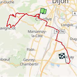

Length
34 km

Max alt
597 m

Uphill gradient
424 m
Km-Effort
40 km

Min alt
213 m

Downhill gradient
547 m
Boucle
No
Creation date :
2014-12-10 00:00:00.0
Updated on :
2014-12-10 00:00:00.0
2h52
Difficulty : Easy

FREE GPS app for hiking
 SityTrail
IGN / Geographical institutes
SityTrail Plus
The world is yours!
About
Trail Mountain bike of 34 km to be discovered at Bourgogne-Franche-Comté, Côte-d'Or, Chenôve. This trail is proposed by phil21.
Positioning
Country:
France
Region :
Bourgogne-Franche-Comté
Department/Province :
Côte-d'Or
Municipality :
Chenôve
Location:
Unknown
Start:(Dec)
Start:(UTM)
650727 ; 5239816 (31T) N.
Comments
roulant