


RANDO VTT LANGLOIS

DANCHAUD
User
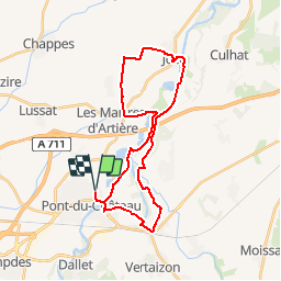

Length
30 km

Max alt
359 m

Uphill gradient
264 m
Km-Effort
34 km

Min alt
292 m

Downhill gradient
264 m
Boucle
Yes
Creation date :
2014-12-10 00:00:00.0
Updated on :
2014-12-10 00:00:00.0
2h00
Difficulty : Easy

FREE GPS app for hiking
 SityTrail
IGN / Geographical institutes
SityTrail Plus
The world is yours!
About
Trail Mountain bike of 30 km to be discovered at Auvergne-Rhône-Alpes, Puy-de-Dôme, Pont-du-Château. This trail is proposed by DANCHAUD.
Positioning
Country:
France
Region :
Auvergne-Rhône-Alpes
Department/Province :
Puy-de-Dôme
Municipality :
Pont-du-Château
Location:
Unknown
Start:(Dec)
Start:(UTM)
519632 ; 5072315 (31T) N.
Comments
Très bonne appli