Trail Walking Moret-Loing-et-Orvanne - 130320-GLM - Moret-MarionRoches - Photo

130320-GLM - Moret-MarionRoches

 randodan
randodan

User

© OpenStreetMap contributors
Length
Length
10.7 km
Max alt
Max alt
113 m
Uphill gradient
Uphill gradient
112 m
Km-Effort
Km-Effort  
12.2 km
Min alt
Min alt
72 m
Downhill gradient
Downhill gradient
114 m
Boucle
Boucle
Yes
Creation date :
2014-12-10 00:00:00.0
Updated on :
2014-12-10 00:00:00.0

(0 Reviews)

Walking
Walking
3h05
Difficulty : Very easy

Scan this QR Code to open this trail in the SityTrail application

FREE GPS app for hiking

Logo SityTrail SityTrail

IGN / Geographical institutes

Download SityTrail from the App Store Download SityTrail from Google Play

Logo SityTrail SityTrail Plus

The world is yours!

Download SityTrail from the App Store Download SityTrail from Google Play Download SityTrail on Huawei AppGallery

About

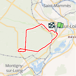
Trail Walking of 10.7 km to be discovered at Ile-de-France, Seine-et-Marne, Moret-Loing-et-Orvanne. This trail is proposed by randodan.

Description

Mercredi matin 20-03-13.<br>
Panique sur l´aqueduc de Médicis qui est en travaux : 100 m de hors piste et ça rouspète.<br>
Pause chamallows et vin chaud sur la croupe à Marion.<br>
Retour par le menhir de l´Escargot (on y était passé le 25 juillet dernier). Les nanas en tête forçant l´allure, on arrive 20 mn avant midi.<br>
5 participants.

Elevation profile

Photos

Points of interest

Point of interest Fontainebleau - Marion des Roches - Photo
randodan
FONTAINEBLEAU 
Point of interest Fontainebleau - Marion des Roches - Photo
randodan
FONTAINEBLEAU 

Positioning

Country:
France
Region :
Ile-de-France
Department/Province :
Seine-et-Marne
Municipality :
Moret-Loing-et-Orvanne
Location:
Moret-sur-Loing
Start:(UTM)
485652 ; 5357270 (31U) N.


Close
My subscriptions