


QUARRE LES TOMBES/ ALLIGNY

DANCHAUD
User
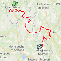

Length
60 km

Max alt
674 m

Uphill gradient
1152 m
Km-Effort
75 km

Min alt
369 m

Downhill gradient
1154 m
Boucle
No
Creation date :
2014-12-10 00:00:00.0
Updated on :
2014-12-10 00:00:00.0
2h00
Difficulty : Unknown

FREE GPS app for hiking
 SityTrail
IGN / Geographical institutes
SityTrail Plus
The world is yours!
About
Trail Other activity of 60 km to be discovered at Bourgogne-Franche-Comté, Yonne, Quarré-les-Tombes. This trail is proposed by DANCHAUD.
Description
ETAPE N°2 DE LA GTM
Positioning
Country:
France
Region :
Bourgogne-Franche-Comté
Department/Province :
Yonne
Municipality :
Quarré-les-Tombes
Location:
Unknown
Start:(Dec)
Start:(UTM)
575249 ; 5246601 (31T) N.
Comments