


SIGNAL D'UCHON / AUTUN

DANCHAUD
User
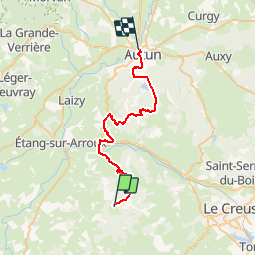

Length
34 km

Max alt
674 m

Uphill gradient
753 m
Km-Effort
45 km

Min alt
275 m

Downhill gradient
1116 m
Boucle
No
Creation date :
2014-12-10 00:00:00.0
Updated on :
2014-12-10 00:00:00.0
2h00
Difficulty : Unknown

FREE GPS app for hiking
 SityTrail
IGN / Geographical institutes
SityTrail Plus
The world is yours!
About
Trail Other activity of 34 km to be discovered at Bourgogne-Franche-Comté, Saône-et-Loire, Uchon. This trail is proposed by DANCHAUD.
Positioning
Country:
France
Region :
Bourgogne-Franche-Comté
Department/Province :
Saône-et-Loire
Municipality :
Uchon
Location:
Unknown
Start:(Dec)
Start:(UTM)
596178 ; 5184502 (31T) N.
Comments